
Where Was The Division Bell Album Cover Taken? Pink Floyd & Ely Cathedral
Released in 1994, The Division Bell marked the second Pink Floyd album since their fractured split with Roger Waters. The record’s heavy, melancholic themes of distance, communication, and fragile, bruised hope demanded a sleeve that felt just as massive. Rather than turning to the digital manipulation beginning to dominate the nineties, designer Storm Thorgerson did what he always did: he built something physical, real, and wonderfully absurd.
To give this new era of the band a monument, Thorgerson commissioned sculptor John Robertson to build two colossal heads—two carved from rough-hewn stone, and two welded from cold, riveted sheets of industrial iron. These giant, multi-tonne faces were hauled into an active agricultural field and meticulously aligned so that the distant, limestone silhouette of Ely Cathedral was perfectly framed in the quiet gap between their lips.
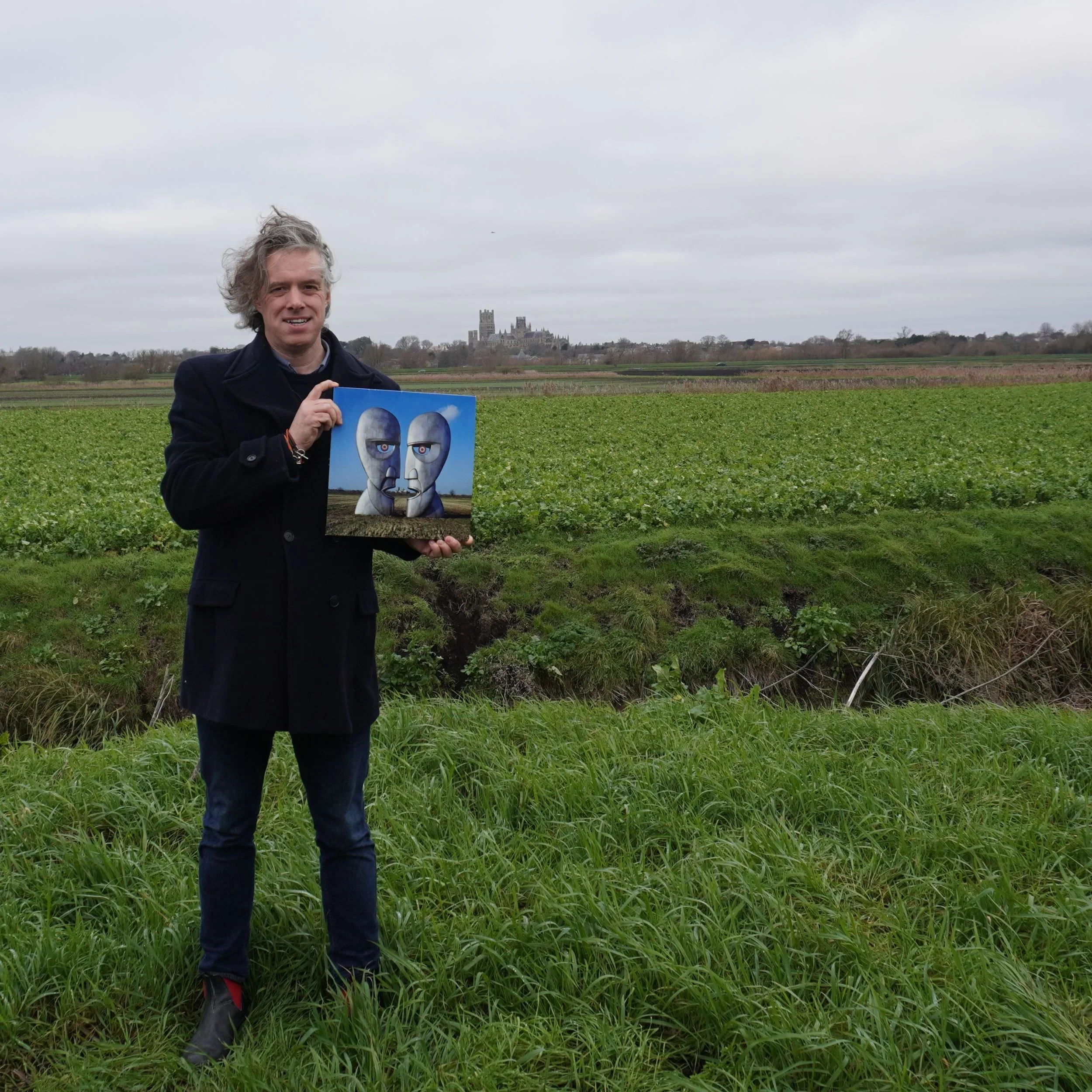
Intrigued by the sheer scale of the project, we packed a vinyl copy of the album and set off on a winter pilgrimage into the grey, wind-swept flatlands of the Cambridgeshire Fens to find the exact spot where this historic photo was taken.
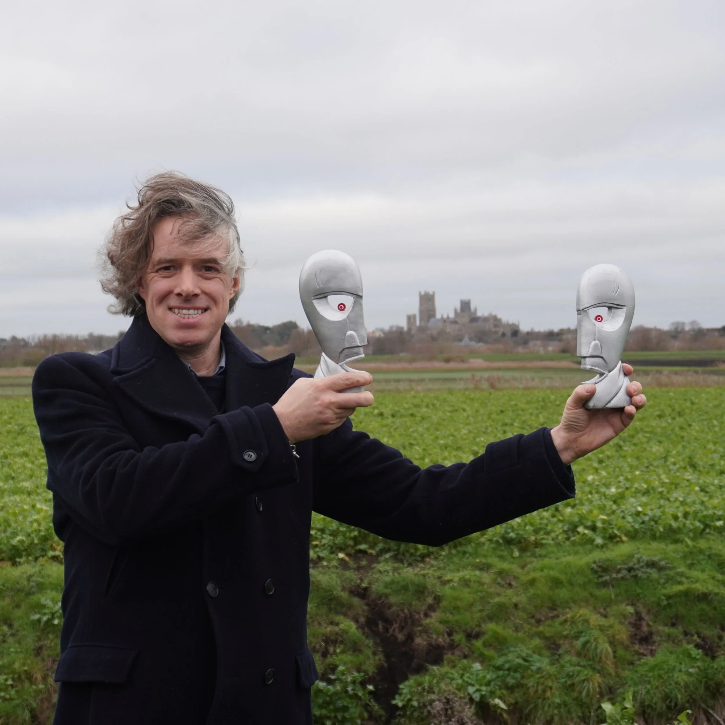
Replica Division Bell heads in Ely
The Album Cover Location: Quanea Drove
The true The Division Bell album cover location is found on the western outskirts of Ely, tucked away off a quiet, sodden agricultural lane called Quanea Drove.
Unlike the busy, modern bypasses that lead into the city, Quanea Drove immediately pulls you into a silent, timeless landscape of dark earth and massive skies. Driving down this single-track road on a freezing morning, the noise of the modern world dropped away entirely, leaving only the damp smell of the soil and the haunting shape of the cathedral on the horizon.
In search of the Division Bell
There are no power lines or pylons here to break the spell. Standing on the frozen verge, the visual weight of the landscape is breathtaking. The cathedral is positioned far enough away to look like a ghostly, fragile memory, yet close enough to retain its immense physical presence, scaling beautifully against the vastness of the empty fields.
Once you stand on the bend of Quanea Drove and see how the landscape opens up, earlier guidebook theories—like David Roberts’ Rock Atlas, which pointed fans toward a cluttered, distant stretch of the A1122 near Stretham—are instantly revealed as wrong.
Why This Specific Landscape Represented the Music
Thorgerson’s choice of this lonely fenland field was not accidental; it was a physical manifestation of the music itself. The Division Bell is a record haunted by the slow breakdown of human relationships. It is a bruised, quiet commentary on the fractured brotherhood between David Gilmour, Nick Mason, Richard Wright, and their long-departed partner Roger Waters.
There is also a deeper, almost biological pull to this flat, watery landscape. This fenland horizon was not selected merely for its desolate aesthetic; it was a quiet return to the soil that birthed the band. Ely sits just fifteen miles north of Cambridge, the ancient city where David Gilmour, Roger Waters, and Syd Barrett first met, dreamed, and walked as schoolboys.
Indeed, the album’s closing masterpiece, “High Hopes”, is a direct, aching look back at those formative Cambridge years—gazing at the horizon of the place they lived when they were young, watching the dawn mist glow along the River Cam. By placing the massive sculptures here, looking back across the flat margins of their youth, the band closed a creative circle.
How to Visit the Location
If you want to make your own pilgrimage to stand in the footprint of Pink Floyd's monoliths, the site is easy to find, provided you treat the rural landscape with care.
The Approach: Take the A142 toward the outskirts of Ely, and turn off directly onto Quanea Drove.
The Vantage Point: Follow the quiet, single-track lane until you hit the first sharp bend. There is a small field opening here with just enough space to safely pull your car onto the hard-standing verge and turn around.
Precise Coordinates: To stand in the exact spot where the sightlines lock onto the cathedral towers, use the What3Words location: ///climber.awkward.indicated
A Note for the Journey: These fields are private, working agricultural farmland. Please remain on the public roadside verge. Do not attempt to cross the deep, wide drainage ditches that border the lane, as they are essential, watery boundaries of the local Fenland landscape.